 FAO Map Catalog
FAO- GeoNetwork
Type of resources
Available actions
Topics
Keywords
Contact for the resource
Provided by
Years
Representation types
Update frequencies
status
Scale
-

Arc-grid "2.5d Hillshade" based derivative of SRTM 3-arc second "Null"set covering Africa, 3204 tiles. Source: FAO
-
"Seamless" set of 3304 Arc-grid based DEM tiles derived from the Version 2 of the SRTM 3 arc second data library covering Africa; nominal 90 metre. Source: NASA/SRTM
-
Derivative of the above "Null" SRTM 3-arc second dataset with terrestrial void areas backfilled with SRTM-GTopo30 DEM, 3204 Arc-Grid tiles. Source: FAO
-
Derivative of the "Baseline" SRTM 3 arc second dataset with ocean and terrestrial void areas set to null using a SRTM-SWBD 1 arc second mask, 3204 Arc-grid based tiles. Source: FAO
-
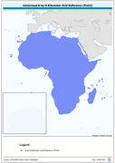
Vectorized 8-by-8 Kilometer Grid Reference (Point). The RFE_PT shapefile data layer is comprised of 471688 derivative calculated precipitation features derived based on 8 kilometers data originally from EDC. The layer provides nominal analytical/mapping at 1:35 000 000. Acronyms and Abbreviations: EDC - USGS EROS (Earth Resources Observation Systems) Data Center.
-
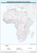
Ad2-Seamless and topologically robust derivative of all linear VMap0 - Ed5 coastal, national, subnational and sovereign boundary data layers cross-checked against related polygonal vectors. The AD2_LN shapefile data layer is comprised of 3656 derivative vector framework library features based on data from VMap0, 5th Edition. The layer provides analytical/mapping at 1:1 000 000. Data processing complete globally, this is an African subset. Acronyms and Abbreviations: VMap0 - Vector Map for Level 0.
-
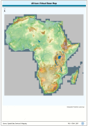
1:750 000 scale seamless base map of continental Africa based on VMap0-Ed3, DCW, and Classified GTopo30 DEM. VMAP0 is Vector Map for Level 0; DCW is Digital Chart of the Word; DEM is Digital Elevation Model.. The VRTL_MAP image data layer is comprised of 51784x51084 derivative image virtual base map features derived based on 1:750 000 data originally from FAO.
-
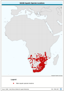
Similar to main aquatic species data layer of capture records of 35 292 verified location references for 247 specie and 1 080 unverified location references for 517 other aquatic specie; includes restricted data for 32 endangered/threatened specie. The AQ_SPECIES shapefile data layer is comprised of 798 derivative point aquatic species features derived based on 1:1 000 000 data originally from FIRI. The layer provides nominal analytical/mapping at 1:1 000 000. Acronyms and Abbreviations: FIRI - Inland Water resources and Aquaculture Service, recently changed in FIMA - Aquaculture Management and Conservation Service
-
Ancillary encoding attribute table.. The FCOD_ALL table data layer is comprised of 87 derivative vector ancillary code descriptor features derived based on 1:1 000 000 data originally from VMap0, 5th Edition. The layer provides nominal analytical/mapping at 1:1 000 000.
-
Cross-Table of Chemistry/Biology data. The WL_CMBIO tabular data layer is comprised of 813 derivative tabular/point limnological, world lakes and rivers features derived based on data originally from FAO. The layer provides nominal analytical/mapping at 1:5 000 000. Acronyms and Abbreviations: FAO - Food and Agriculture Organization in the United Nations.